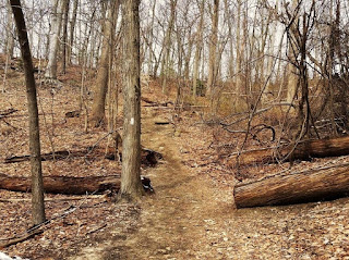
Location: Cold Spring Harbor, NY
Size: 40 acres
Date of hike: March 5, 2016
Cold Spring Harbor State Park is probably the hilliest hike I've done on Long Island. It was recommended to me by a local hiker who stumbled across my blog and sent me an encouraging e-mail, which I appreciated. He also noticed I'd yet to visit Cold Spring Harbor State Park. Well, with no specific plans when I woke this past Saturday, it seemed like a perfect day to head over and explore it. In a nutshell, these hills are a thrill.
Prior to hiking, I briefly researched the history and habitats of Cold Soring Harbor State Park, which has a hilly terrain that offers scenic vistas of the picturesque Inner Harbor. "It features a mixed hardwood forest with large oak specimens that can measure three feet in diameter, as well as thickets of wild mountain laurel," the New York State Office of Parks, Recreation and Historic Preservation's website said. The site was among land purchased by New York State in the 1960s and was initially intended to host part of a bridge to Connecticut that was proposed by urban planner Robert Moses, according to The New York Times. The property was later brought to the state's attention by a librarian seeking space for a new building and was formally dedicated as a park in 2000. It also connects to Bethpage State Park through Trail View State Park, which is a 7.4-mile linear park located on the former right-of-way for a proposed extension of the Bethpage State Parkway, and it serves as the northern trailhead for the 20-mile Nassau-Suffolk Greenbelt Trail. A trail map is linked on the state's website.
The entrance is on the east side of Harbor Road just north of the Cold Spring Harbor Library. Although there was enough room for dozens of cars almost every parking space was taken, reminding me
of something that the hiker who recommended the park stated in his e-mail: "This path can get very
crowded, which is the only bad thing about it."
Boy, was he right. One hiker was a dude extensively stretching as he readied for a rapid ascent up the first section of the trail, which consisted of a series of logs and planks serving as a staircase. Seconds later, he raced up them as
if he were in a marathon. I followed him up the steps, but at my own pace. To my delight, the payoff was immediate as breathtaking views of the harbor can be seen as soon
as you reach the first hilltop. I should also note that the trail's highest point tops out at approximately 250 feet, according to the website Hiking Project.
The hike's highlight for me was the endless undulating hills that filled the out-and-back trail, which spans 1.14 miles from the trailhead to Lawrence Hill Road. It took me a half hour to reach the end, at which point I hydrated and then began my retreat back to the parking lot. Interestingly, this is the only local park so far where I have seen hikers use trekking poles, which took me back to the time I hiked last spring in New Hampshire's White Mountains. Everyone used trekking poles up there, but elevation gains here are so minimal that you rarely see them used on Long Island. On a related note, I read the park is also open to snowshoeing and cross-country skiing when there are at least three inches of snowfall.
The hike's highlight for me was the endless undulating hills that filled the out-and-back trail, which spans 1.14 miles from the trailhead to Lawrence Hill Road. It took me a half hour to reach the end, at which point I hydrated and then began my retreat back to the parking lot. Interestingly, this is the only local park so far where I have seen hikers use trekking poles, which took me back to the time I hiked last spring in New Hampshire's White Mountains. Everyone used trekking poles up there, but elevation gains here are so minimal that you rarely see them used on Long Island. On a related note, I read the park is also open to snowshoeing and cross-country skiing when there are at least three inches of snowfall.
Regarding wildlife, the park hosts spring and fall
migrations of various songbirds as well as great horned owls and
red-tailed hawks. You'll also see a ton of dogs. I blocked out their barks by setting my beloved iPod to play Riverside's first album, Out of Myself, from 2004. I've always
been a casual fan of the Polish progressive metallers, but I started to sink my
teeth further into their music since the sudden passing of their guitarist
Piotr Grudziński. This album can take me on an
emotional journey like few others. Rest in peace, Piotr.
In closing, I'd definitely recommend hiking Cold Spring Harbor State Park if you're up for the hill-filled challenge. While I probably passed a total of about 40
hikers, which prevented me from getting lost in thought as I usually do on my hikes, that's a small price to pay for
such priceless views. In fact, it's a
bargain, if you ask me. Just don't forget your trekking poles.
(Updated: Jan. 7, 2023)
Parking: 40°52'03.1"N 73°27'42.3"W


Concur on everything you've said about CSH. Its easily the most challenging start to a trail we've ever come upon in years of hiking this island. There is always a collection of makeshift walking sticks at the kiosk at the start of the trail, left for others by those who knew enough to need them. After our first visit, we always grabbed a pair.
ReplyDeleteAnd yes, Asians. Very noticeable. We thought that perhaps it had something to do with proximity to the Cold Spring Harbor Laboratory. On one particular visit an ancient, tiny Japanese woman cheerfully informed us that she was there in training for an upcoming trip to Japan to climb Mount Fuji.
C. Andy