 Laurel Ridge Setauket Woods Nature Preserve
Location: Setauket, NY
Size: 252 acres
Date of hike: June 8, 2019
Laurel Ridge Setauket Woods Nature Preserve is a sprawling park used for hiking and biking just north of NY Route 347. I intended to hike nearby Patriot's Hollow State Forest, which I recently read added 17 acres as part of an acquisition by the New York State Department of Environmental Conservation, but trails have yet to be cleared there. That caused me to pull over, pull up Google Maps, and discover Laurel Ridge Setauket Woods Nature Preserve. Minutes later, I was there.
My pre-hike research told me the land was deeded to the Town of Brookhaven in the 1980s when a developer gave his development rights to the town, which then dedicated it in 2009, according to a press release on the town's website. "By dedicating Laurel Ridge Setauket Woods Nature Preserve, the Town of Brookhaven is ensuring that clean water – millions of gallons a year – is recharged in perpetuity," Assemb. Steve Englebright (D-Setauket) said, noting that the area recharges roughly 143 million gallons of clean drinking water annually and is among only three "deep-flow recharge zones" on Long Island. "The preservation of [the preserve] also protects a museum piece of our terrestrial natural history and ensures that future generations will have access to stunningly beautiful glacial moraine woodland," the press release stated. Speaking of its woodland, the region features a pine-oak forest along with an extensive understory of mountain laurel. And as for its name, Laurel Ridge comes from the fact that the land sits on the Harbor Hill Terminal Moraine, the town said.
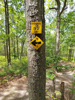
The preserve's entrances are located on the east and west sides of North Belle Mead Road, only a few blocks north of NY Route 347. When I arrived, a handful of cars were parked on the shoulders of both sides of the road, and I joined them on the street's east side near the trailhead for the East Setauket Mountain Bike Trail. The parcel apparently has 13 miles of paths maintained by CLIMB, which stands for Concerned Long Island Mountain Bicyclists. "The east side is comprised of 18 miles of single track," said the mountain-biking website VisionMTB. "The main loop is approximately 5.5-miles long and has various switchbacks and moderate climbs and downhills. It's also relatively smooth with a few roots and small rocks along the way." In addition, a trailhead sign said there are several levels of difficulty marked with a green circle, blue square and black diamond – the later of which is hardest.
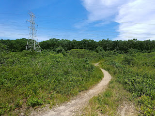
The hiking itself was delightful, although it was hard to know which direction I was walking in due to the frequently zigzagging nature of bike trails. If you've been to David Overton Trail or Edgewood Oak Brush Plains Preserve, you'll know what I mean. It's also important to stay extra alert on bike trails, because the riders can come upon you without warning. Luckily, there weren't too many, but I made sure to wear only one earbud so I'd hear them coming. The trail took me east and south past a string of power lines and down to NY Route 347, then looped back north. I also saw several signs for a "bailout," which was helpful since there are often no easy ways back once you're out in no man's land on a long bike trail.
With regard to wildlife, the preserve has a wide variety of migratory songbirds, woodpeckers, game birds, small mammals, reptiles, amphibians and numerous invertebrates, according to VisionMTB. The trails are also open to dog walkers, as I saw the preserve recommended on the website Wagwalking.com. "You'll want to keep your dog on a leash at all times, both for his own safety and the safety of others," the website said. As for music, I listened to a mix of progressive metal headlined by Redemption's 2018 album, Long Day's Journey Into Night.
All in all, I'd say Laurel Ridge Setauket Woods Nature Preserve is worth a visit, but mostly if you like long-distance hiking. This is a park where you're cranking out miles, as opposed to enjoying a leisurely stroll. And, of course, keep your head on a swivel and beware of bikes!
Map: Laurel Ridge Setauket Woods Nature Preserve (Google Maps image)
Parking: 40°54'25.3"N 73°05'24.0"W
Video: Laurel Ridge Setauket Woods Nature Preserve (360-degree view)


Thank you for article.
ReplyDelete